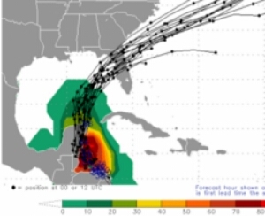
Hurricane hunter aircraft have reported finding tropical storm force winds of 40 mph turning the third tropical depression of the season into Tropical Storm Colin.
That’s according to the latest update from the National Hurricane Center. The NHC has been sending hurricane hunter aircraft into the system to monitor its development for the past several days.
The National Weather Service has tropical storm warnings in place from Englewood near the Charlotte and Sarasota County line northward toward the “big bend” area of the state along the panhandle.
Thanks to a large trough of low pressure swinging through the center of the United States, the steering winds over the Gulf will push the developing system toward the northeast and closer to Florida by Monday.
The expected exact track of this system will take the low pressure center (the middle of the storm) near the “big bend” area of north Florida.
Although the low will pass to the north of Southwest Florida it’s important to note the majority of the storm’s rain is on the eastern side of it. That means central and southern Florida will be in a favorable area for stormy weather.
Spells of heavy rain and the opportunity for a few rounds of strong to severe thunderstorms will be possible over the state, including Southwest Florida, on Monday and Tuesday.
Some storms may produce damaging wind gusts and a few isolated tornadoes will be possible as well. As far as rain, periods of heavy rain will likely bring between 2 to 5 inches of rain through Monday night.
Secondary concerns will be compliments of hours on onshore south and southwest winds. That will lead to open seas in the Gulf of Mexico building above 6 feet and possibly some minor beach erosion along Florida’s west coast.