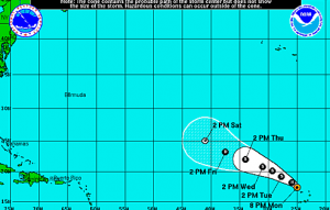
 At 800 PM AST (0000 UTC), the center of Hurricane Fred was located near latitude 17.4 North, longitude 25.0 West. Fred is moving toward the northwest near 12 mph (19 km/h), and this motion is expected to continue through tonight. A turn toward the west-northwest is expected on Tuesday. On the forecast track, the center will be moving away from the Cape Verde Islands.
Despite Fred’s dramatic arrival to the hurricane season its long-term future does not look bright. The northwest path Fred is on will put it in the vicinity of much cooler waters by the end of the work week. Cooler waters are not favorable for hurricanes and tropical storms to survive.
The northwest path will also steer Fred into an area where the air is comparatively drier and where more wind shear is present in the atmosphere. Both of these factors will help to weaken the storm substantially by Friday.
Maximum sustained winds have decreased to near 75 mph (120 km/h) with higher gusts. Weakening is forecast during the next couple of days.
Hurricane force winds extend outward up to 15 miles (30 km) from the center and tropical storm force winds extend outward up to 80 miles (130 km).
The estimated minimum central pressure is 992 mb (29.29 inches).