It has been just over five weeks since Florida experienced the landfall of Hurricane Ian. And with many in Southwest Florida still picking up the pieces, a new storm will likely be impacting the state of Florida later this week.
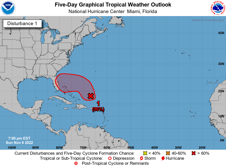
The National Hurricane Center (NHC) in Miami is tracking Invest 98L, a still disorganized tropical wave located more than 200 miles north of Puerto Rico. NHC is currently giving the system an 80% chance of tropical formation over the next 2 days and a 90% chance over the next 5 days. The system is forecast to move northward over the next day or so before working its way back to the southwest on Tuesday through Wednesday as it works its way back toward the East Coast of Florida.
Right now, forecast models strengthen Invest 98L into a tropical depression on Monday then Tropical Storm and/or Hurricane strength by Wednesday. The next two names on the list are Nicole and Owen (which one this is named depends on if Invest 97L in the Atlantic is named first).
The East Coast of Florida will likely see coastal flooding and beach erosion, with much of Florida seeing tropical storm-force winds, heavy rainfall, and the possibility of an isolated tornado or two on the northern side of the eventual track.
There are a few factors as to track and intensity that have yet to be worked out, as the timing of the storm and the timing of a cold front will be critical. Here are a few scenarios:
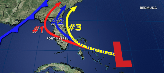
One scenario is a low-end Category 1 hurricane making landfall near West Palm Beach on Wednesday night/Thursday morning with a cold front moving into the Florida panhandle on Thursday into Friday. This is the most likely scenario currently and reflected in track #1. That would push the system across the state of Florida and back into the Gulf of Mexico around Sarasota. The cold front would then pull the storm northeastward and away from Florida. That would mean Southwest Florida would likely see tropical, squally downpours, especially in Sarasota, DeSoto, Charlotte, Glades, and Lee Counties with wind ranging from 35 to 55 mph. With many homes still covered with a tarp on the roof, it would be important to make sure that it is secured. Also, power infrastructure that is “band-aided” post-Hurricane Ian could be impacted.
Now if that crossover is further south, then winds could be closer to 45 to 65 mph. That is still tropical storm strength. Additionally, a weaker storm, as some models suggest, then this would be more of a pure scattered rain flooding event, in lower laying areas.
If the system is slower and the cold front arrives still on Friday or vis vera, then the storm will turn northeastward hugging Florida’s east coast, reflected in track #3. This scenario has a low chance of happening at this time but would bring scattered showers and thunderstorms to Southwest Florida, more typical of rainy season afternoon storms. This would bring us little to no impact.
If the storm is somewhere in-between, seen in track #2, then Southwest Florida would still likely see tropical, squally weather would more mostly limited to the north-most locations.
It is important to note this is not another Ian for Southwest Florida, as this storm will have little to no storm surge impacts on our counties. But it is also important to be weather aware the next few days.
NHC says they will likely start to issue watches and warnings as early as Monday morning.