Tropical Depression Fred Intermediate Advisory Number 17A
NWS National Hurricane Center Miami FL AL062021
…DISORGANIZED FRED CONTINUES TO SPREAD HEAVY RAINFALL OVER
PORTIONS OF CENTRAL CUBA…
SUMMARY OF 800 PM EDT…0000 UTC…INFORMATION
———————————————-
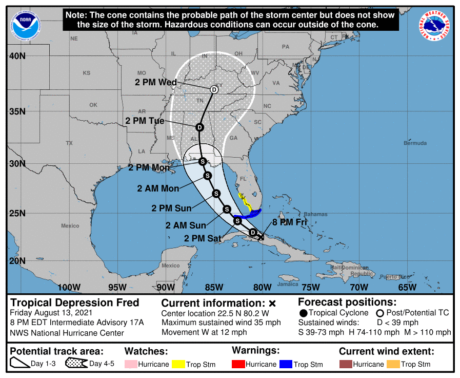
LOCATION…22.5N 80.2W
ABOUT 45 MI…70 KM W OF CAIBARIEN CUBA
ABOUT 175 MI…285 KM SE OF KEY WEST FLORIDA
MAXIMUM SUSTAINED WINDS…35 MPH…55 KM/H
PRESENT MOVEMENT…W OR 280 DEGREES AT 12 MPH…19 KM/H
MINIMUM CENTRAL PRESSURE…1013 MB…29.92 INCHES
WATCHES AND WARNINGS
——————–
CHANGES WITH THIS ADVISORY:
None
SUMMARY OF WATCHES AND WARNINGS IN EFFECT:
A Tropical Storm Warning is in effect for…
* The Florida Keys west of Ocean Reef to the Dry Tortugas
* Florida Bay
A Tropical Storm Watch is in effect for…
* The southwest coast of Florida from Englewood south and east to
Ocean Reef
A Tropical Storm Warning means that tropical storm conditions are
expected somewhere within the warning area within 36 hours.
A Tropical Storm Watch means that tropical storm conditions are
possible within the watch area.
Interests in the Bahamas, Cuba, and in the Florida peninsula and
Florida Panhandle should monitor the progress of Fred. Additional
watches and warnings could be required for portions of the west
coast of Florida and the Florida panhandle tonight or Saturday.
For storm information specific to your area in the United
States, including possible inland watches and warnings, please
monitor products issued by your local National Weather Service
forecast office. For storm information specific to your area
outside of the United States, please monitor products issued by
your national meteorological service.