…POTENTIAL TROPICAL CYCLONE OVER THE SOUTHWESTERN GULF OF MEXICO……EXPECTED TO BRING HEAVY RAINFALL AND FLOODING TO THE NORTHERN GULF COAST…NHC is issuing advisories on Potential Tropical Cyclone Three, located over the Gulf of Mexico about 475 miles south of Morgan City, La. A subtropical or tropical depression or storm is likely to form over the west-central Gulf of Mexico tonight or early Friday.
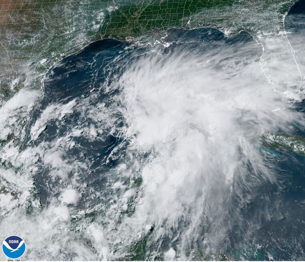
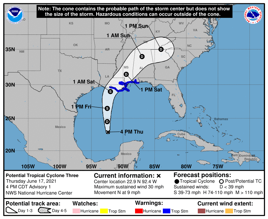
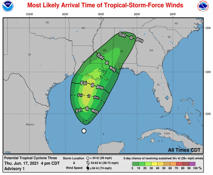
The system is moving toward the north near 9 mph (15 km/h) and this motion with some increase in forwarding speed is expected for the next day or so. On the forecast track, the system will approach the north-central Gulf Coast late Friday or early Saturday. A northeastward motion across the southeastern United States is likely after landfall.
A Tropical Storm Warning has been issued for the Gulf Coast from Intracoastal City, La., to the Alabama/Florida state line, including Lake Pontchartrain, Lake Maurepas, and Metropolitan New Orleans. Tropical storm conditions are expected to first reach the coast within the warning area on Friday, making outside preparations difficult or dangerous.
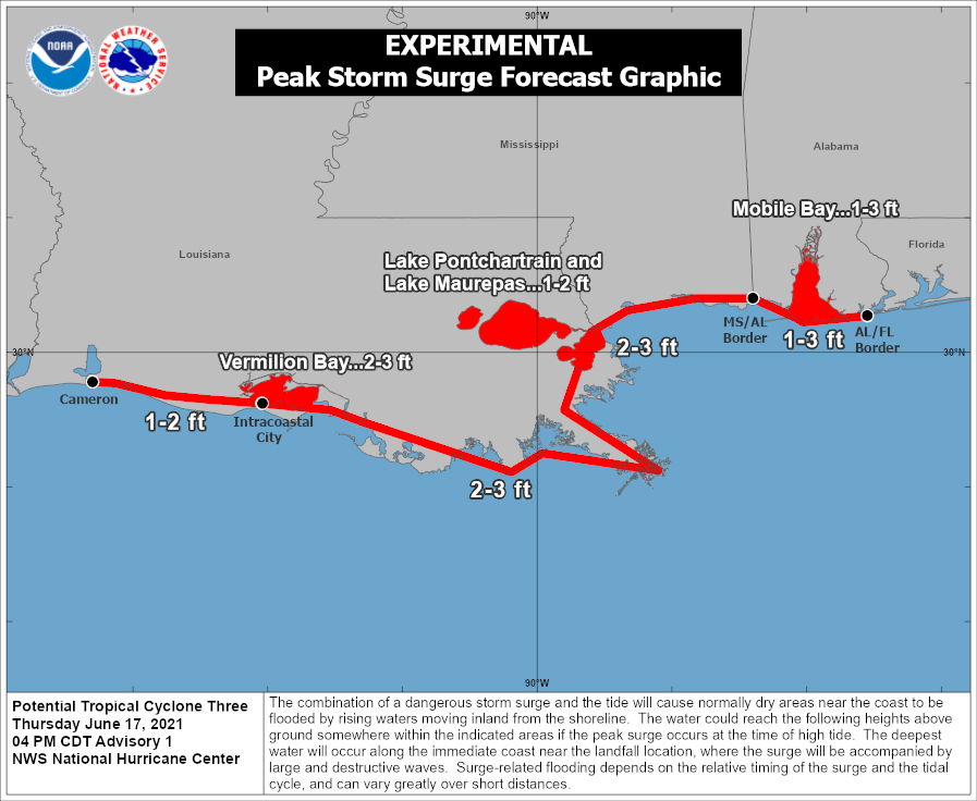
Maximum sustained winds are near 30 mph (45 km/h) with higher gusts. Some strengthening is forecast to occur tonight and Friday. Should these sustained winds reach 40 mph, the system will be given the name “Claudette” .The combination of storm surge and the tide will cause normally dry areas near the coast to be flooded by rising waters moving inland from the shoreline. The water could reach the following heights above ground somewhere in the indicated areas if the peak surge occurs at the time of high tide…Intracoastal City, LA to MS/AL State line…2-3 ftVermilion Bay and Lake Borgne…2-3 ftvLake Pontchartrain and Lake Maurepas…1-2 ft MS/AL border to AL/FL State line including Mobile Bay…1-3 ft Cameron, LA to Intracoastal City, LA…1-2 ft The potential tropical cyclone is expected to produce total rainfall of 3 to 6 inches with isolated amounts of 8 inches across the Yucatan Peninsula of Mexico. Rainfall totals of 4 to 8 inches with isolated maximum amounts of 12 inches are possible beginning Friday and continuing through the weekend from the Central Gulf coast northeastward into the Southern Appalachians. This will likely produce areas of flash, urban, and small stream flooding as well as minor to isolated moderate river flooding with new and renewed rises on already elevated rivers.
The threat for a couple of tornadoes should begin Fridayafternoon across coastal Louisiana. This threat should expand northward across southern portions of Louisiana and Mississippi, and southwest Alabama on Saturday.
The next complete advisory will be issued by NHC at 10 p.m. CDT with an intermediate advisory at 7 p.m. CDT – www.hurricanes.gov