 TROPICAL WEATHER OUTLOOK
NWS NATIONAL HURRICANE CENTER MIAMI FL
200 PM EDT SUN JUL 31 2016
For the North Atlantic…Caribbean Sea and the Gulf of Mexico:
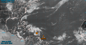
1. Showers and thunderstorms associated with a strong and fast-moving tropical wave over the eastern Caribbean Sea have changed little in organization this morning, and there are still no signs of a closed surface circulation. Although some gradual development of this system is possible during the next day or so, the chance for tropical cyclone formation should increase after the wave reaches the western Caribbean Sea in a couple of days. This disturbance is expected to cause locally heavy rains and gusty winds over portions of the Lesser Antilles, the Virgin Islands, and Puerto Rico today and tonight. These conditions should spread westward across the central Caribbean Sea and reach Hispaniola by Monday and Jamaica and Cuba by Tuesday. Interests in these areas and elsewhere in the Caribbean Sea should continue to monitor the progress of this system. For additional information on this system, see High Seas Forecasts issued by the National Weather Service.
* Formation chance through 48 hours…medium…40 percent
* Formation chance through 5 days…high…70 percent