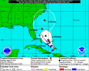
 The fourth tropical depression of the season formed around 5:00 pm Saturday over the Turks and Caicos Islands.
Hurricane Hunters out investigating the storm determined the system had a well-defined center of circulation, even though much of its activity was displaced to the east of the center.
TD #4 had winds of 35 mph and was moving in a general northwest direction at 12 mph, with a slight turn to the NNW expected late Sunday into Monday.
The storm will affect the Turks and Caicos, along with the southeastern Bahamas tonight. It will pass near or over the Central Bahamas Sunday into Monday as it moves into a break in the subtropical ridge of high pressure. The storm is expected to drop between 4 and 8 inches of rain, with isolated areas of up to 12 inches there.
Beyond the next 36 to 48 hours, the subtropical ridge is expected to strengthen to the east side of the storm sending it in a more northerly to northeasterly direction.
A majority of the the forecast models keep the storm to the east of the Florida peninsula, with only a few models bringing it out into the gulf.
The forecast track from the National Hurricane Center has the farthest western fringe of the cone of uncertainty only brushing the Space Coast, and not making landfall in the state.
That forecast track does have the storm potentially becoming a category one hurricane by midweek.